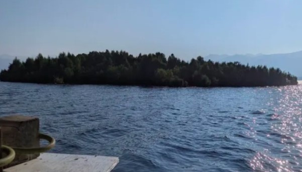
A tree-covered “island” in Canada left residents and reservoir officials thoroughly puzzled. The island appeared to be floating in the middle of Williston Reservoir, British Columbia, before vanishing from satellite imagery entirely.
Some time later, the island was found again. It hadn’t sunk, it had drifted roughly 30 kilometers from its original location. This phenomenon took place at Williston Reservoir, British Columbia’s largest reservoir. The floating island is estimated to measure roughly 140 x 70 meters, covering nearly 9,800 square meters.
First Spotted by Boaters in August
Its appearance was first reported by residents out boating in mid-August. Video footage showing a small landmass, complete with trees, quickly began circulating on social media.
At first, officials from BC Hydro even suspected the video might have been fabricated. Bob Gammer from BC Hydro told the BBC he initially thought the footage might have been AI-generated.
“I thought, this could be anywhere. Maybe it’s not even real,” he said, as quoted by the BBC.
Confirmed by Satellite, Then It Disappeared Again
That doubt faded once BC Hydro’s team checked satellite imagery. An image dated July 21, 2026, did indeed show an island-like object floating on the reservoir. But a new problem emerged when the team tried to track it, in satellite imagery from August 5, the island was no longer visible at its original location.
“We genuinely had no idea where the island had gone. Had it sunk? Had it drifted to another corner of the reservoir?” Gammer said.
Solving the Mystery: It Had Drifted 30km Away
The mystery was finally solved after subsequent satellite images and reports from several witnesses showed the island had ended up in the Ospika Arm area, roughly 30 kilometers from its starting point.
BC Hydro confirmed this location on August 31, based on satellite imagery dated August 15, along with observations from a small aircraft and residents out on boats.
So the island hadn’t mysteriously vanished, it had simply broken free and drifted. BC Hydro estimates the island traveled roughly 30 kilometers over the course of 15 days.
How Does a Floating Island Like This Even Form?
Phenomena like this are actually possible on large reservoirs, though a floating island of this size is considered unusual. The leading hypothesis is that the island formed from piles of wood and organic material that accumulated over the years along a sheltered edge of the reservoir.
Logs that fall into the water can pile up on top of one another. Over time, this material decomposes and becomes a base for moss, plants, and even trees to grow. Plant roots then help bind the material together into a fairly large, relatively stable mass.
When water levels rise significantly, that mass can lift away from the shoreline and begin floating. Gammer explained the process with a simple analogy: a fallen tree trunk can sit in place for a long time, then plants, moss, and even new trees start growing on top of it.
A rise in water level can eventually lift the entire mass away from where it originally formed. BC Hydro considers this mechanism the best current theory explaining the island’s origin.
Not Solid Ground, More Like a Giant Natural Raft
Although it looks like a solid patch of land, this structure is actually more akin to a giant natural raft. Inside it are logs, roots, decomposing plant material, along with soil and vegetation all bound together.
Because of this, its surface is unstable. BC Hydro has warned the public not to attempt to land on or walk across it. “Stay away from the island. It could break apart,” BC Hydro stated.
This warning isn’t without reason. Large waves and strong winds on the reservoir could damage the collection of wood and organic material forming the island. If it breaks apart, the mass could turn into scattered debris across the water.
About Williston Reservoir
Williston Reservoir itself is an artificial reservoir formed after the construction of the W.A.C. Bennett Dam on the Peace River. The reservoir began filling in 1968 and spans roughly 1,773 square kilometers at full capacity.
The sheer size of this body of water makes even an object dozens of meters wide difficult to track. Ironically, it was satellite technology that ultimately helped solve the mystery.
Satellite imagery dated July 21 showed the island’s original position, while imagery from August 15 revealed its location in the Ospika Arm area. Aerial observations and resident reports then helped confirm that the object seen in both locations was indeed the same mass.
A Small, Wandering Ecosystem
This case shows that natural phenomena that seem mysterious can often be explained once different types of observation are combined. From the shore, an island might appear to simply materialize and then vanish. From satellites, its journey can be traced.
And from an ecological standpoint, this “island” turned out to be a small, wandering ecosystem, formed from trees and organic material accumulated over years, then set loose by changing water conditions.
BC Hydro itself acknowledges there are still unanswered questions, particularly regarding the exact process behind how this mass formed.
“Finding the island answered one question, but it also raised several others,” Gammer said.
“We still need to study how the island formed and how it managed to drift across the reservoir,” he added.